SummaryShort Description: Eight days of trekking connecting Choquequirao with Machu Picchu along ancestral trails. You descend into the Apurímac canyon, climb to the Cradle of Gold, cross the San Juan Pass at 4,650 meters with views of the Choquetacarpo glacier, and finish at the wonder of the world. 100 kilometers of mountain. Two Inca citadels. One single expedition.
Tour Name: Choquequirao to Machu Picchu
Subtitle: The traverse that connects the two sister citadels
This is the classic route connecting Choquequirao with Machu Picchu. It begins in Cachora, the traditional access point to the Cradle of Gold, and ends eight days later at the most famous citadel in the world.
The first three days take you to Choquequirao through the Apurímac canyon. It is the same route as the classic 4-day trek, but instead of returning the way you came, you continue forward. On the fourth day you cross the San Juan Pass at 4,650 meters — the highest point of the trek — with views of the Choquetacarpo glacier and the snow-capped peaks of the Vilcabamba mountain range. The following days you descend toward the high jungle, passing through remote communities and landscapes that shift from highland puna to tropical forest.
On the seventh day you arrive in Aguas Calientes to rest. On the eighth day you visit Machu Picchu and return to Cusco by train.
That is 100 kilometers of walking that traverse all the ecological zones of Andean Peru. Few treks in the world offer this combination of history, landscape, and physical challenge.
Itinerary
Day 1
Cusco → Cachora → Chiquisca
Distance: 12 km Elevation change: -1,500 m Walking time: 6–7 hours
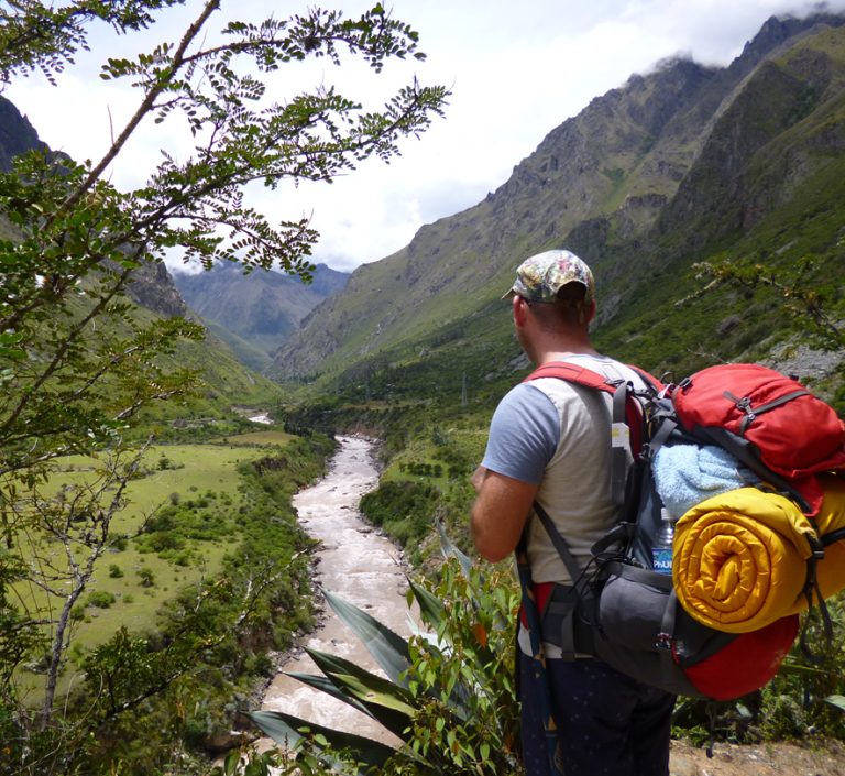
Departure from Cusco at 5:00 in the morning. 4-hour private vehicle transfer to Cachora, passing through Limatambo and the Apurímac River valley. Breakfast in Cachora with views of the Padreyoc snow-capped peak. Registration at Capuliyoc (2,900 m) and start of the trek. The trail descends steadily into the Apurímac canyon, one of the deepest on the planet. The path is well-marked with panoramic views that open up as you descend.
Lunch stop at Cocamasana with views of the canyon. In the afternoon, the descent continues through vegetation that transitions from highland puna to dry forest.
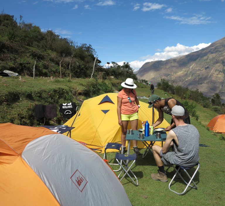
Arrival at Chiquisca (1,900 m) in the late afternoon. Camp setup. Dinner and overnight in tents.
Accommodation: Camping in Chiquisca | Meals: Breakfast, Lunch, Dinner
Day 2
Chiquisca → Choquequirao
Distance: 8 km Elevation change: +1,500 m Walking time: 6–7 hours
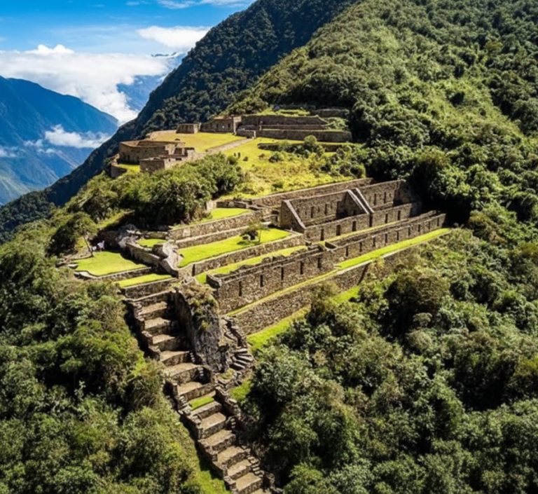
Early breakfast. 45-minute descent to Playa Rosalina (1,550 m), the lowest point of the trek. Crossing of the Apurímac River over a suspension bridge. The most demanding ascent of the trek begins. The first 3 hours involve constant gradient up to Santa Rosa. The trail winds through cacti, agaves, and dry slope vegetation. Brief rest at Marampata (2,850 m) with the first view of Choquequirao in the distance. Final hour of gentler walking through orchids and bromeliads to the entrance of the complex. Arrival at Choquequirao (3,050 m) at midday. Lunch with views of the ruins. In the afternoon, first guided exploration of the main sector: the Haucaypata plaza, the main temple, and the ceremonial terrace system.
Sunset on the terraces. Dinner and overnight at the campsite within the archaeological complex.
Accommodation: Camping in Choquequirao | Meals: Breakfast, Lunch, Dinner
Day 3
Choquequirao Exploration → Pinchauniyoc
Distance: 10 km Elevation change: +400 m / -600 m Time: 6 hours
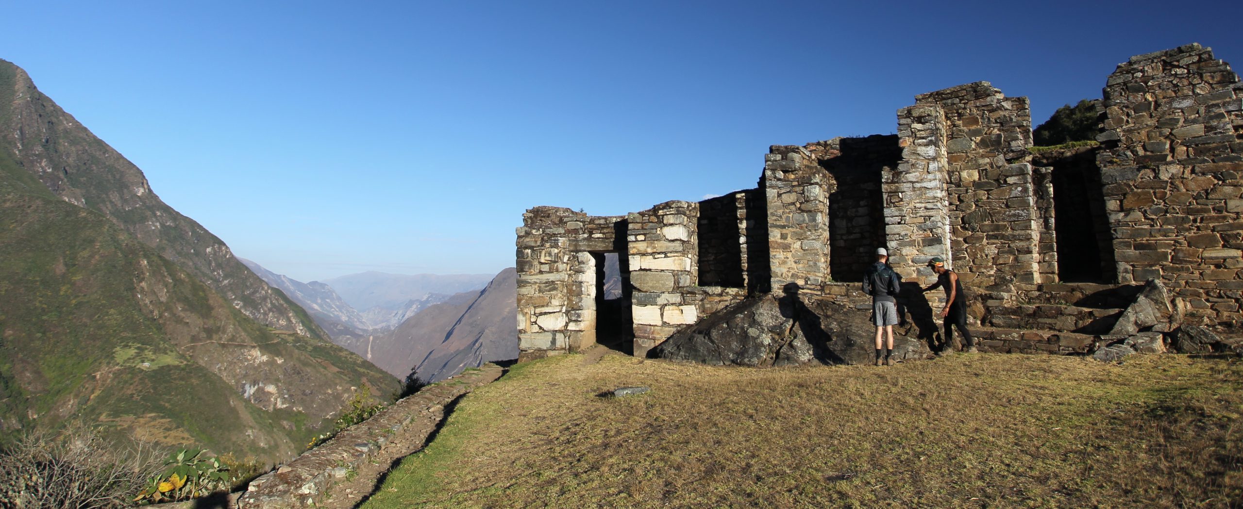
Sunrise at Choquequirao for those who want to watch the sun rise over the mountains. Breakfast at the campsite. Morning dedicated to exploring the more remote sectors of the complex: the llama sector with its 24 terraces decorated with white stone carvings, the priests’ quarter, and the viewpoints overlooking the Apurímac canyon.
Farewell lunch at the site. In the early afternoon, the walk begins heading north, in the opposite direction from the arrival route. The trail climbs toward the Pinchauniyoc sector, an extension of Choquequirao with more terraces and partially excavated structures. The path continues along the mountain ridge with views of the canyon on both sides. Arrival at the Pinchauniyoc campsite in the late afternoon.
Dinner and overnight in tents.
Accommodation: Camping in Pinchauniyoc | Meals: Breakfast, Lunch, Dinner
Day 4
Pinchauniyoc → San Juan Pass → Yanama
Distance: 16 km Elevation change: +1,600 m / -950 m Time: 8–9 hours
The longest and most challenging day of the trek. Breakfast before dawn and departure at 5:30. The trail ascends constantly from Pinchauniyoc (2,850 m) to the San Juan Pass (4,650 m). Approximately 5 hours of climbing through terrain that shifts from cloud forest to high-altitude grassland. At the pass opens the most spectacular panorama of the trek: the Choquetacarpo glacier gleams ahead, the snow-capped peaks of the Vilcabamba mountain range extend in every direction. This is the highest point of the expedition and one of the most impressive viewpoints in Peru. With luck, Andean condors can be spotted soaring over the canyon.
Lunch at the pass or on the first section of the descent, depending on weather. In the afternoon, a 3–4 hour descent to Yanama (3,700 m), a small muleteer village in the valley.
Approximate arrival at 4:30 in the afternoon. Camp setup. Dinner and overnight in tents.
Accommodation: Camping in Yanama | Meals: Breakfast, Lunch, Dinner
Day 5
Yanama → Totora → Collpapampa
Distance: 14 km Elevation change: -900 m Time: 6–7 hours
Breakfast and departure at 7:00. The trail descends gradually into the Totora valley, leaving the high-altitude zone behind and entering a more temperate climate. The path passes through small Quechua communities engaged in subsistence farming. The landscapes shift from highland grassland to cultivated fields and then to greener vegetation. Stop in Totora for lunch. The village has small shops where you can buy extra snacks or drinks. In the afternoon, the descent continues to Collpapampa (2,800 m), following the course of the river. The climate becomes noticeably warmer. Arrival at the campsite in the late afternoon.
Dinner and overnight in tents.
Accommodation: Camping in Collpapampa | Meals: Breakfast, Lunch, Dinner
Day 6
Collpapampa → La Playa → Santa Teresa
Distance: 18 km Elevation change: -1,300 m Time: 7–8 hours
The longest day in terms of distance. Early breakfast and departure at 6:30. The trail continues descending through the valley, now deep in the cloud forest zone. The vegetation is lush: giant ferns, orchids, bromeliads, and moss-covered trees. The climate is warm and humid. Stop at La Playa for lunch. From this point there is the option to continue walking or take transport to Santa Teresa (to be coordinated with the guide based on the group’s condition).
Arrival in Santa Teresa (1,500 m) in the late afternoon. Hotel check-in. Free time to visit the Cocalmayo hot springs — the perfect reward after six days of walking. The natural hot-water pools sit alongside the Urubamba River.
Dinner and overnight at the hotel.
Accommodation: Hotel in Santa Teresa | Meals: Breakfast, Lunch, Dinner
Day 7
Santa Teresa → Aguas Calientes
Transport: 30 min by vehicle + 1.5 hours by train
Free morning to rest, return to the hot springs, or simply recover your energy. After six days of trekking, this transition day allows you to arrive at Machu Picchu without exhaustion. Lunch in Santa Teresa. Midday departure to the Hidroeléctrica train station (30 minutes by vehicle).
Afternoon train to Aguas Calientes. The journey follows the course of the Urubamba River between mountains covered in tropical vegetation. Arrival in Aguas Calientes in the late afternoon.
Hotel check-in. Rest of the afternoon free to explore the town or rest before the final day.
Dinner and overnight in Aguas Calientes.
Accommodation: Hotel in Aguas Calientes | Meals: Breakfast, Lunch, Dinner
Day 8
Machu Picchu → Cusco
Time at Machu Picchu: 3–4 hours Transport: Bus + train
Very early breakfast. Departure at 5:30 to catch one of the first buses to Machu Picchu. The ascent takes 25 minutes. Entry to the citadel at 6:00 in the morning. This is the best time: few people, soft light, and the possibility of watching the mist rise between the mountains. 2-hour guided tour of the main sectors: the central plaza, the Intihuatana, the Temple of the Sun, the Temple of the Three Windows, the ceremonial fountains, and the agricultural sector. The guide explains the history, architecture, and significance of each area.
Free time until 10:00 to explore independently, photograph, and absorb the place.
Bus descent to Aguas Calientes. Time for lunch at your own expense (not included).
14:55 train to Ollantaytambo. Approximate arrival at 16:30. Private vehicle transfer to Cusco. Arrival in the city at 18:00.
End of services.
Meals: Breakfast
Included
Private transport Cusco – Cachora
Train Santa Teresa → Aguas Calientes
Train Aguas Calientes → Ollantaytambo
Private transport Ollantaytambo → Cusco
Bus up and down to Machu Picchu
5 nights camping (double tents, sleeping pads)
1 night at a hotel in Santa Teresa (double room)
1 night at a hotel in Aguas Calientes (double room)
Professional bilingual guide throughout the expedition
Guide at Machu Picchu
Expedition cook
Muleteers and pack mules
All meals as per itinerary (7 breakfasts, 7 lunches, 7 dinners)
Boiled and purified water throughout the trek
Trail snacks
Choquequirao entrance fee
Machu Picchu entrance fee
Dining tent with table and chairs
First aid kit
Emergency oxygen
Trekking poles (on loan)
Not Included
Sleeping bag (rental available: $30 USD)
Lunch on Day 8 in Aguas Calientes
Entry to Cocalmayo hot springs (~$5 USD)
Tips for the team (suggested: $80–120 USD total)
Additional drinks
Travel insurance (mandatory)
Personal expenses
Price
From $1,450 USD per person Price based on a group of 4 or more people.
Group size
Price per person
2 people
$1,750 USD
3 people
$1,550 USD
4+ people
$1,450 USD
Private group
Contact us
What to Bring
Day pack (20–30 liters)
Layered walking clothes
Waterproof jacket
Warm jacket for the high-altitude pass
Worn-in trekking boots
Sneakers or sandals for rest
Swimwear for the hot springs
Sun hat and cold-weather hat
Light gloves
Sunscreen SPF 50+
UV-protection sunglasses
Headlamp with extra batteries
Water bottle (minimum 2 liters)
Personal hygiene items
Personal medication
Insect repellent (for the jungle days)
Camera
Cash for extras and tips
Recommendations
Arrive in Cusco a minimum of 2–3 days early to acclimatize
Train with 15–20 km hikes in the weeks leading up to the trip
Test your boots before the trip
Consult a doctor about altitude sickness medication
Purchase travel insurance with trekking coverage above 4,500 meters
Pack clothing for varied climates: intense cold at the pass, humid heat in the jungle
Difficulty Level
High This 8-day trek covers 100 kilometers with a mountain pass at 4,650 meters. Day 4 (San Juan Pass) is the most demanding, with nearly 1,600 meters of positive elevation gain.
It requires good physical fitness and the ability to walk 6–9 hours per day for several consecutive days. Prior experience in multi-day trekking is recommended but not mandatory.
Departures
Mondays and Fridays with a minimum of 2 people. Recommended season: April to November (dry season) Possible with precautions: December and March Not operated: January and February (heavy rains)